The ANCIENT Megalithic Architecture of the Americas
Jan 13, 2025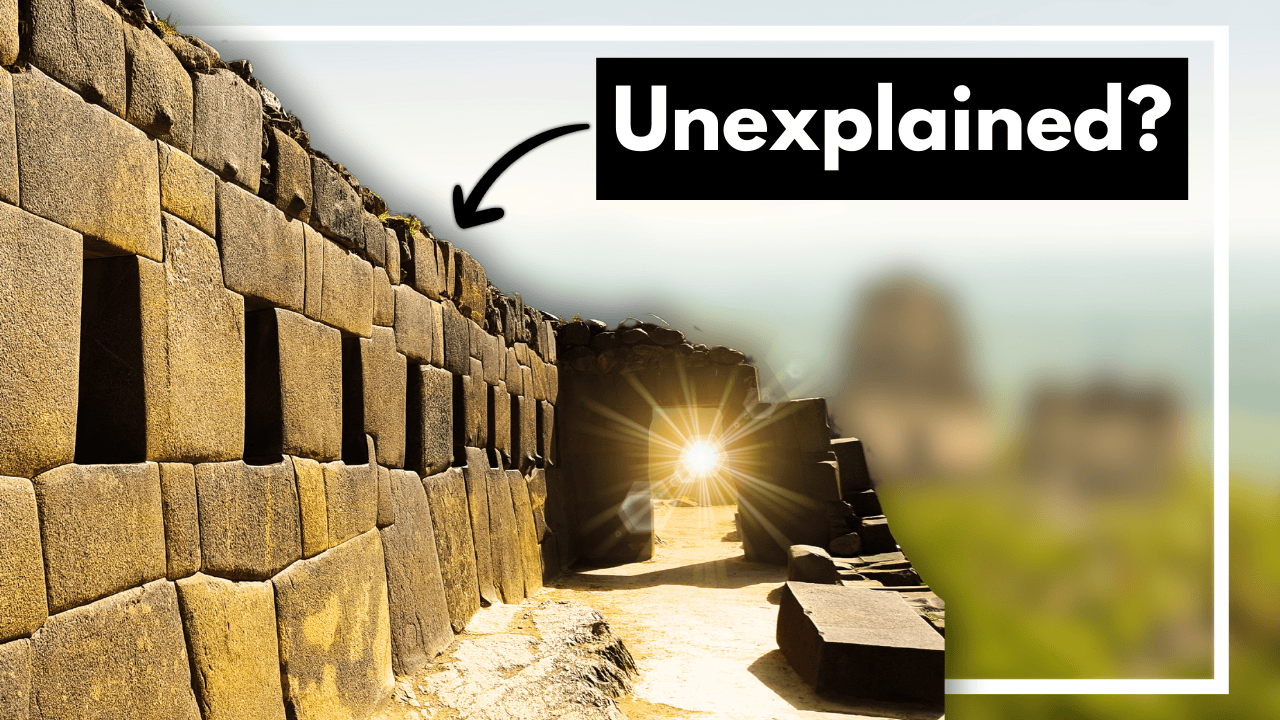
By: Greg Schmalzel
Beneath the dense forests and sweeping jungles of the Americas, hidden away from the modern world, lie monuments of ancient power and mystery. These colossal structures, many of which predate even the great pyramids of Egypt, stand as silent testaments to the ingenuity of early civilizations. But who built them and why?
In South America, the monumental stonework of Caral Supe and Tiwanaku baffles archaeologists even today. In Central America, the Maya, Olmec, and Aztecs left behind towering temples, intricately carved stones, and colossal heads—works of engineering that seem impossible for their time. And in North America, the earthen mounds of Poverty Point and Cahokia form sprawling complexes that stretch across the landscape.
These remarkable structures share a common thread: they were built without the wheel, without industrial metal tools, and without our modern understanding of the world. Yet, they continue to stand, defying time and the elements. They hold within them the stories of people whose cultures once flourished. What drove these ancient peoples to construct such awe-inspiring monuments? And what secrets do these megaliths still hold?
Join me as we explore the megalithic architecture of ancient America, and discover the beautiful stonework of a distant past.
For the full video version, CLICK HERE.
Origins of the Americas
By at least 20,000 years ago, people were living in the Americas, likely migrating from Siberia by foot or boat. These early inhabitants were nomadic hunter-gatherers, moving in small groups to follow prey and forage for food. Over time, they developed distinct cultures, such as the Clovis Culture. Their lifestyle centered around mobility, making permanent settlements unnecessary.
Around 5,000 years ago, agricultural societies began emerging across the Americas, leading to permanent settlements and the rise of complex civilizations. In Mesoamerica, the Maya and Olmec built impressive cities, while Andean cultures, like those at Caral, created monumental structures. This shift paved the way for the megalithic architecture that characterizes many post-hunter-gatherer societies.
Megalithic architecture, defined by large stone structures, appears throughout the Americas in diverse forms—ranging from single monuments, like the Olmec heads, to vast constructions made from countless stone blocks. Since the scope is too broad to cover entirely, this video highlights select examples. Let’s start our journey in South America and gradually head north.
South America
Caral-Supe
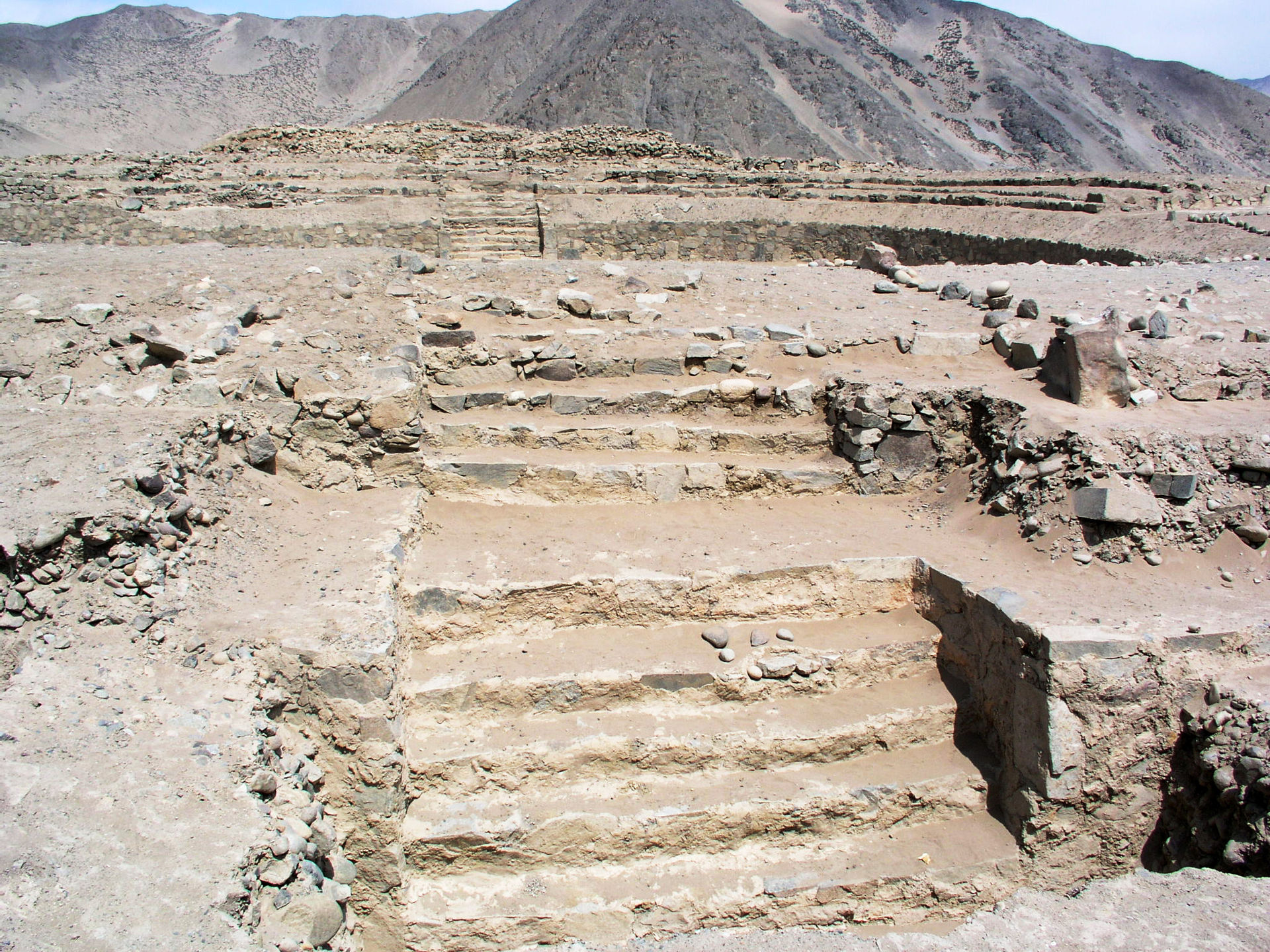
Caral-Supe, located in the Supe Valley of Peru, is one of the oldest urban centers in the Americas, often referred to as the cradle of South American civilization. Situated 23 km inland from the coast, Caral’s ancient ruins sit atop terraces overlooking the Supe River floodplain. The city’s most striking features are its large stone mounds, which resemble pyramids. Initially appearing as natural hills, closer inspection reveals carefully crafted stone structures exposed through erosion and archaeological excavation. At the heart of Caral lie six prominent mounds, with the largest, known as Pyramid Mayor, measuring 160 by 150 meters at its base and standing 18 meters high. Built in two phases, the pyramid's construction required immense labor and materials, demonstrating advanced planning and organization. Even the smallest of these structures, measuring 60 by 45 meters and 10 meters tall, rivals the size of half a football field, indicating the scale and ambition of Caral’s builders.
The significance of Caral extends beyond its architecture. Excavations reveal that the central mounds were likely used for residential, ceremonial, and administrative purposes. Circular sunken plazas surrounding the mounds suggest communal gatherings, religious ceremonies, or governance. According to archaeologist Ruth Shady Solis, Caral’s architectural layout, which integrates platform mounds and sunken plazas, became a hallmark of Andean ceremonial complexes for thousands of years. The construction process involved cut-stone retaining walls filled with rubble and cobbles transported in shicra bags, a type of woven mesh. These retaining walls were once covered in vibrant layers of plaster, adding an aesthetic dimension to the monumental structures. Radiocarbon dating indicates Caral's origins trace back at least 4,000 years, with some estimates suggesting construction began as early as 5,000 years ago—predating the pyramids of Egypt.
Caral’s economy thrived on maritime resources, supporting the hypothesis of the Maritime Foundations of Andean Civilization. This theory posits that the rich fisheries along the coast provided the surplus necessary to sustain urban centers. Archaeological findings at Caral include large quantities of fish remains, particularly anchovies and sardines, which were dried and traded inland. In exchange, coastal communities received cotton from valley cultivators, essential for crafting fishing nets that enhanced maritime productivity. This reciprocal trade network fostered economic stability and supported the construction of Caral’s monumental architecture. While agriculture played a role, with crops like squash and beans cultivated nearby, marine resources likely formed the backbone of the economy. Caral challenges the notion that agriculture alone drives early urbanization, illustrating how trade and resource management can also facilitate complex societal development.
Machu Picchu

In contrast, Machu Picchu, built in the 15th century by the Inca, stands as a testament to their architectural and engineering prowess. Nestled high in the Andes at nearly 8,000 feet above sea level, this mountaintop citadel seamlessly blends with the surrounding landscape. Rediscovered in 1911 by Hiram Bingham, Machu Picchu's construction remains shrouded in mystery, particularly regarding the precision of its stone masonry. Massive limestone and granite blocks, some weighing several tons and standing over 13 feet tall, were quarried, transported, and fitted together without mortar. Key architectural features include the agricultural terraces, designed to prevent erosion and enhance fertility through intricate drainage systems composed of gravel and sand layers. Structures such as the Temple of the Sun, with trapezoidal windows aligned to solar events, reflect the Inca's astronomical knowledge and spiritual practices.
Machu Picchu exhibits at least three distinct architectural styles, hinting at possible phases of construction by different cultures. The oldest, monolithic style—referred to as Hanan Pacha—consists of large stones carved directly from the mountain’s rock. The second, characterized by Cyclopean masonry, features interlocking stone blocks fitted without mortar, exemplifying the earthquake-resistant design prevalent in Inca architecture. The third style comprises smaller, rough stones set in irregular courses with mortar, often layered atop earlier structures. This stratification suggests that the Inca may have inherited and expanded upon the work of earlier civilizations. Theories surrounding the precision of Inca stonework range from traditional chiseling to speculative ideas involving acid-based techniques for softening stone. Together, Caral-Supe and Machu Picchu highlight Peru’s rich archaeological heritage, offering insight into the diverse pathways through which early civilizations in the Americas developed monumental architecture and complex societies.
Mesoamerica
The Olmec
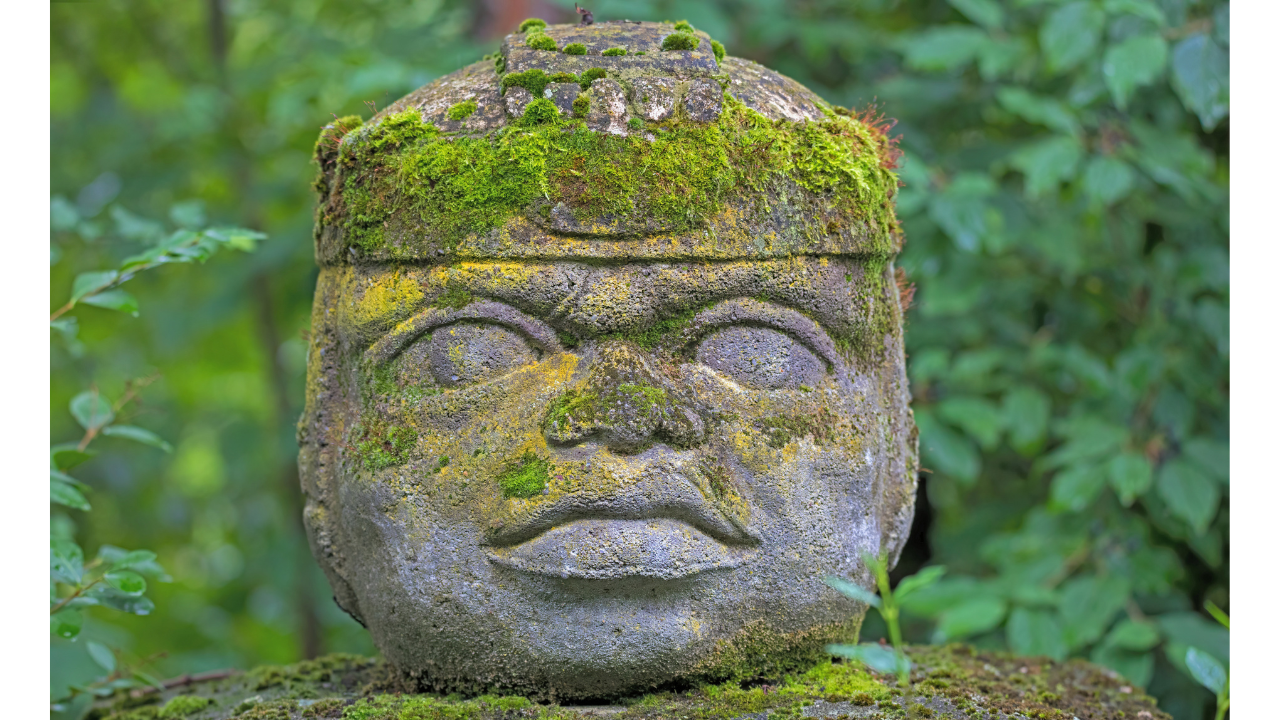
The Olmec were the earliest widespread civilization in Mesoamerica, flourishing along Mexico’s Gulf Coast from around 1600 to 400 BC. Known as the “mother culture” of the region, they left behind colossal stone heads, some over 10 feet tall and weighing up to 40 tons, likely depicting rulers or deities. These heads, carved from basalt with distinct facial features and helmets, showcase the Olmecs' advanced engineering and organizational skills.
The basalt used for the heads was quarried from the Sierra de los Tuxtlas mountains, about 50 miles from where the heads were found. Despite lacking animal labor or industrial tools, the Olmec transported these massive stones—possibly by dragging them with sleds or floating them on rafts—demonstrating impressive logistical coordination.
Key sites like La Venta and San Lorenzo feature monumental platforms, pyramids, and ball courts, reflecting early ceremonial and cultural developments. At La Venta, a large rectangular pyramid dominates the site, while altars carved with jaguar, serpent, and human motifs highlight the Olmec’s artistic and religious expressions. This tradition of monumental art and architecture laid the foundation for later Mesoamerican civilizations like the Maya and Aztecs.
The Maya
Ed Barnhardt’s work on Maya architecture, particularly through the Palenque Mapping Project, has significantly advanced understanding of the ancient city of Palenque in Chiapas, Mexico. Between 250 and 900 AD, Palenque served as a major Maya capital. Barnhardt’s team mapped 220 hectares over 18 months, recording 1,481 structures and 16 km of terracing—far exceeding the previously known 329 structures. This dense urban layout, with population estimates between 1,885 and 2,827 people per square km, highlights Palenque’s advanced urbanism. Barnhardt emphasizes the city’s focus on public infrastructure, such as terraces and canals, reflecting a civic-minded leadership dedicated to improving urban living conditions.
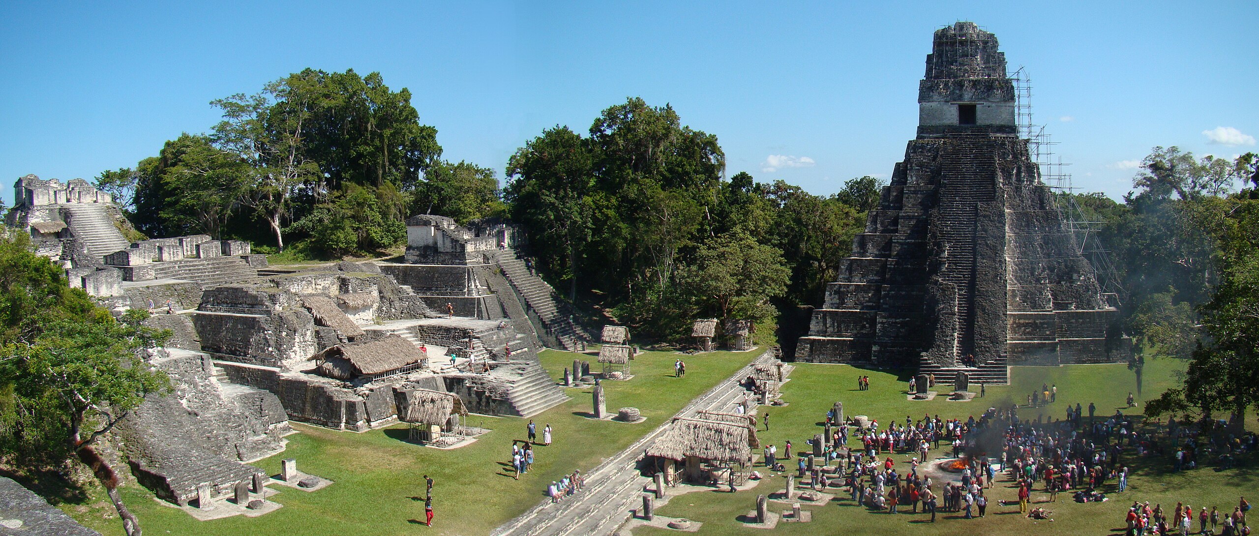
In contrast, Tikal in Guatemala represents a grander, more expansive form of Maya urbanism. Tikal’s iconic Temple I, or the Temple of the Great Jaguar, was constructed around 734 AD as a funerary monument for ruler Jasaw Chan K'awiil I. Rising 47 meters, its nine stepped levels symbolize the Maya underworld. Built from local limestone, the temple features a stucco exterior once painted red and white, linking the structure to solar deities. A roof comb at the top visually extends its height, reinforcing the power of the interred ruler. The tomb beneath held valuable jade artifacts and ceramics, showcasing Tikal’s wealth.
Palenque’s tightly packed, cooperative urbanism contrasts with Tikal’s monumental scale, underscoring the diversity in Maya city planning and societal priorities. Each site reflects unique adaptations to environment and governance, contributing to the broader complexity of Maya civilization.
The Aztec
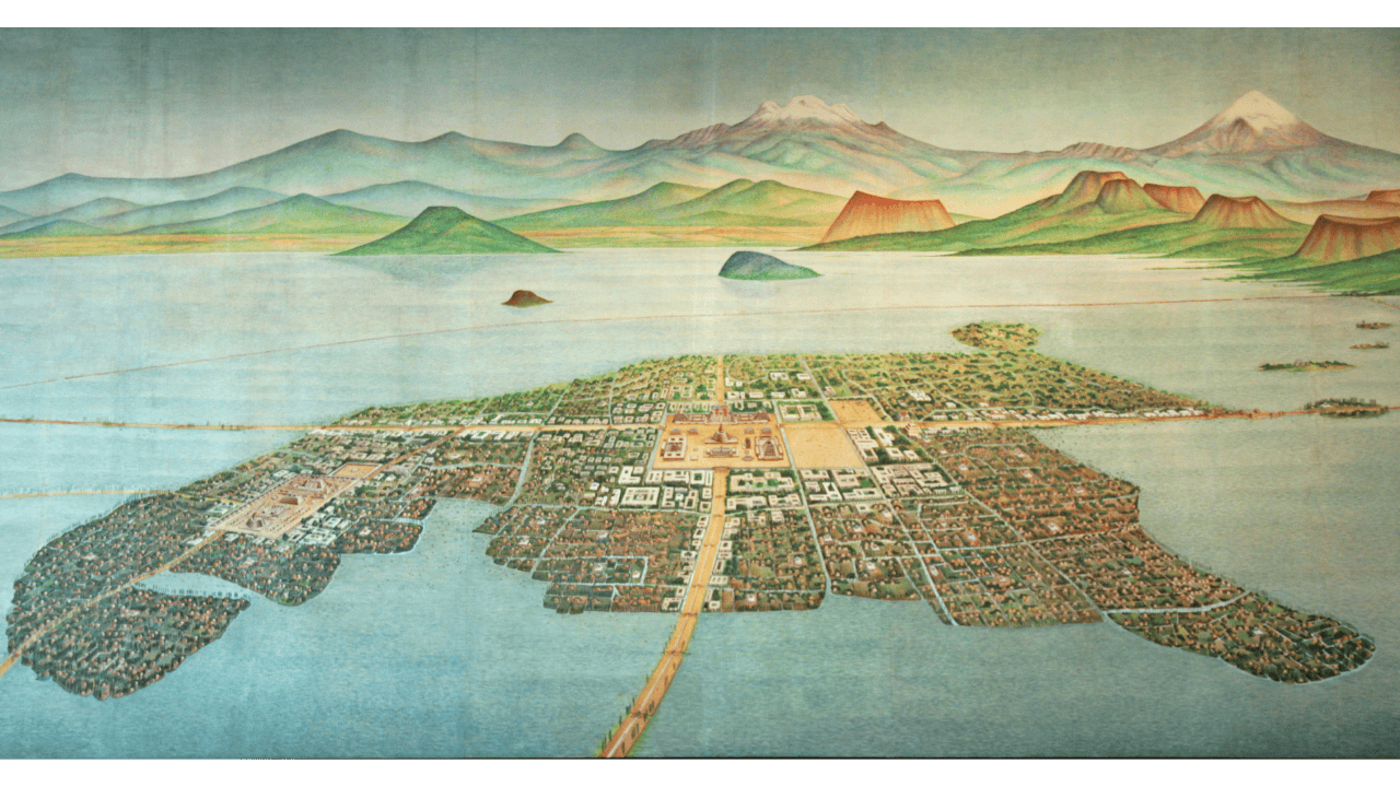
The Aztecs rose to prominence in the Valley of Mexico, building monumental architecture that reflected their imperial ambition. Unlike the rainforest cities of the Maya, the Aztec capital, Tenochtitlán, stood at the center of a lake system, connected by causeways and aqueducts. Founded in 1325 and lasting until the Spanish conquest in 1521, Tenochtitlán’s short but impactful existence showcased remarkable engineering and urban planning.
Despite the marshy, submerged land of Lake Texcoco, the Aztecs transformed the landscape with causeways, dikes, and floating gardens, supporting a population of over 200,000. The city was divided into four districts radiating from the sacred center, home to Templo Mayor—one of the most iconic structures. This step pyramid, built in seven stages, featured twin shrines atop dual staircases. The southern shrine honored Huitzilopochtli, god of war and the sun, while the northern shrine was dedicated to Tlaloc, god of rain and fertility. At 60 meters high, Templo Mayor dominated the skyline and served as the site for ritual sacrifices.
Archaeological excavations have uncovered sacrificial stones, ceremonial artifacts, and human remains, highlighting the temple’s role in Aztec religious life. Templo Mayor symbolized the dual forces of fire and water, representing both creation and destruction at the heart of Aztec belief. The grandeur of Aztec architecture reflected a society shaped by war and sacrifice, but also immense creative and engineering potential. Had their focus shifted from conquest to growth and beauty, Tenochtitlán might have evolved into an enduring, utopian metropolis.
North America
North American archaeology reveals a rich and complex prehistoric landscape, often overlooked compared to the iconic pyramids of Egypt and Mesoamerica. Massive structures exist in North America as well, though they are distinct in form and material.
During the Archaic period (10,000 to 3,000 years ago), following the Paleoindian period and preceding the Woodland period, early monumental structures began to emerge. This era saw shifts in climate, regional specialization, and the diversification of stone tools.
Unlike the megalithic stone architecture of Mesoamerica, North American structures are primarily earthen mounds. Early examples include shell mounds along coastal plains and rivers, often composed of oyster, mollusk, and clam shells. Some served as refuse from food gathering, while others held funerary significance.
True earthen mounds, made from massive amounts of soil, became prominent in the eastern woodlands. Sites like Watson Brake and Jaketown are notable, but Poverty Point and Cahokia stand out as key examples of North America’s impressive prehistoric engineering.
Poverty Point

Poverty Point in northeastern Louisiana is one of North America's most remarkable archaeological sites, built by indigenous peoples between 3700 and 3100 years ago. This complex predates many other monumental constructions, highlighting the engineering and social complexity of pre-agricultural societies.
Situated on the Macon Ridge above the Mississippi River floodplain, the site offered protection from flooding and access to wetland resources rich in fish, game, and waterfowl. Its location near rivers facilitated trade, making Poverty Point a center for long-distance exchange.
The site’s defining features include six concentric earthen ridges forming a semicircle around a large central plaza, with wooden structures likely lining the ridges. Mound A, the largest mound, rises over 70 feet and required the movement of 750,000 cubic meters of earth—achieved without heavy machinery or domesticated animals. This reflects advanced planning, social organization, and possibly celestial or cosmological influences on the design.
Poverty Point challenges assumptions about early societies, as its large-scale construction was undertaken by hunter-gatherers rather than agricultural communities. This suggests leadership, ritual, and social stratification played key roles in mobilizing labor for communal projects.
Artifacts from the site reveal extensive trade networks, with materials like copper from the Great Lakes and shells from the Gulf Coast, underscoring its role as a cultural and economic hub. Though eventually abandoned for reasons unknown, Poverty Point’s significance endures, earning recognition as a UNESCO World Heritage Site in 2014. It stands as a testament to the ingenuity of ancient hunter-gatherers in North America.
Cahokia
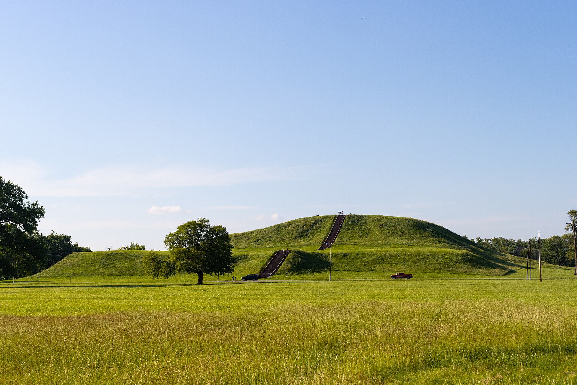
Cahokia, located near St. Louis, Missouri, thrived between 1050 and 1350 AD and was the largest pre-Columbian archaeological site north of Mexico, representing the height of Mississippian culture. At its peak, the city had a population of 10,000 to 20,000, surpassing many European cities at the time.
Cahokia’s strategic location at the confluence of the Mississippi, Missouri, and Illinois Rivers provided access to abundant resources and trade networks, fostering intensive agriculture, particularly maize cultivation, which supported its growth. The city’s monumental earthen mounds, including the largest, Monks Mound, reflect impressive engineering and social organization. Monks Mound, over 100 feet high and 14 acres in size, likely served as the political and ceremonial center of the city.
Cahokia had over 120 mounds, including platform, conical, and ridge-top mounds, suggesting a highly organized labor force capable of executing large-scale projects. The city’s layout featured a central plaza, a palisade wall for defense, and wooden circles known as "Woodhenge" believed to be solar calendars, showcasing advanced astronomical and ceremonial knowledge.
The city’s social structure was hierarchical, with elites living on platform mounds, and its thriving artisan class engaged in long-distance trade. Despite its grandeur, Cahokia declined around 1350 AD, possibly due to environmental, resource, or social factors. Its legacy challenges traditional views of pre-Columbian societies, highlighting their ability for urban planning, social complexity, and monumental architecture.
Conclusion
The Americas are littered with diverse examples of monumental architecture and we still don’t know the specifics as to how many of them were built, especially that mortarless masonry of the Inca. That said, to truly understand the forces that drove their construction, we must consider a common theme - the role of religion and storytelling in motivating these people. For a deeper dive into traditional, non-Western religions, make sure you check out my video on Animism. It will give you a better understanding of how many of these belief systems may have emerged.
Sources:
[1] Pigati, J., et al. 2023. “Independent age estimates resolve the controversy of ancient human footprints at White Sands.” Science 382:73-75.
[2] Pringle, H. 2001. “The First Urban Center in the Americas.” Science 292:621-621.
[3] Solis, R., et al. 2001. “Dating Caral, a Preceramic Site in the Supe Valley on the Central Coast of Peru.” Science 292:723-726.
[4] Beresford-Jones, D., et al. 2018. “Refining the Maritime Foundations of Andean Civilization: How Plant Fiber Technology Drove Social Complexity During the Preceramic Period.” J Archaeol Method Theory 25:393–425.
[5] Wright, K., et al. 1999. “Ancient Machu Picchu Drainage Engineering.” Journal of Irrigation and Drainage Engineering 125(6):360 - 369
[6] Scherrer, D. 2018. “Ancient Observatories - Timeless Knowledge.” Stanford University Solar Center.
[7] The rise of Inca Empire | Ed Barnhart and Lex Fridman
[8] The Olmec Legacy
[9] Coe, Michael. 2017. America’s First Civilization. Horizon.
[10] Coe, Michael D., Urcid, Javier. Koontz, Rex. 2019. Mexico. From the Olmecs to the Aztecs. Thames & Hudson Ltd.
[11] Barnhardt, E. 2001. “The Palenque Mapping Project: Settlement and Urbanism at an Ancient Maya City.” University of Texas at Austin Doctorate Dissertation.
[10] Bonfitto, P. 2021. “World Architecture and Society: From Stonehenge to One World Trade Center.” ABC-CLIO.
[12] Wedekind, W., et al. 2011. “Natural building stones of Mexico–Tenochtitlán: their use, weathering and rock properties at the Templo Mayor, Palace Heras Soto and the Metropolitan Cathedral.” Environ Earth Sci 63:1787–1798.
[13] Aguilar Moreno, M. “AZTEC ARCHITECTURE.”
[14] Aveni, A., et al. 1988. “Myth, Environment, and the Orientation of the Templo Mayor of Tenochtitlan.” American Antiquity 53(2):287-309.
[15] Poverty Point: Archaic Anomaly?
[16] Poverty Point Culture and the Jaketown Site: New Insights on the Apex of Archaic Monumentality
[17] Grooms, S. 2022. “Reassessing the History of the Poverty Point Phenomenon: A Reassessing the History of the Poverty Point Phenomenon: A Case Study from the Jaketown Site, Mississippi, USA Case Study from the Jaketown Site, Mississippi, USA.” Washington University Doctorate Dissertation.
[18] Cahokia: Mississippian Metropolis
[19] Rankin, C., et al. 2021. “Evaluating narratives of ecocide with the stratigraphic record at Cahokia Mounds State Historic Site, Illinois, USA.” Geoarchaeology 36(5).
[20] Iseminger, William. Cahokia Mounds: America's First City. History Press, 2011.
Founder