Integrating Artificial Intelligence into GIS-Based Archaeological Research
Dec 09, 2024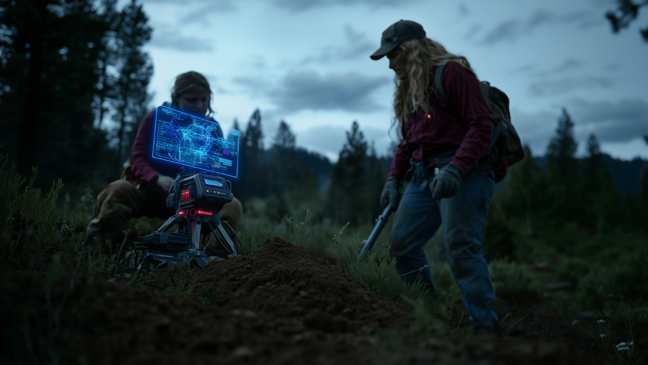
By: Richard J. Ott – MA, RPA
Archaeologists have long grappled with the complexities inherent in cultural landscapes, working with incomplete datasets and the need to contextualize spatial information within broader social, environmental, and historical frameworks (Conolly and Lake 2006; McCoy 2022). Integrating AI into GIS offers promising avenues for examining large datasets derived from remote sensing imagery, legacy site records, and environmental metrics. These tools streamline detecting subtle patterns and generate predictive models that can guide field surveys, heritage management, and interpretive synthesis (Menze and Ur 2012; Trier et al. 2019).
Yet, as promising as these technologies are, they must be employed with a critical sensibility. Automated classifications and predictions are not answers unto themselves. They require interpretive frameworks grounded in archaeological theory and collaborative research practices. Scholars emphasize not only the analytical promise of AI but also the responsibility to ensure that data-intensive approaches remain accountable to ethical imperatives, transparent methodologies, and community-informed perspectives (Driskill 2018; Supernant 2021; Flewellen 2020; Geller 2017; McDavid 2019). By integrating these considerations, researchers can harness AI’s strengths while focusing on cultural knowledge, heritage protection, and interpretive depth.
Historical Context and Theoretical Underpinnings
Early attempts to integrate AI into archaeology in the 1980s and 1990s were limited by computational constraints, resulting in simplistic pattern recognition and classification tasks (Esri 2023; QGIS Documentation 2023). Advances in machine learning (ML) and deep learning models subsequently led to refined methods capable of detecting subtle spectral or topographic anomalies associated with archaeological deposits (Menze and Ur 2012; Smith and Parsons 2020). The incorporation of convolutional neural networks (CNNs) and other advanced algorithms enabled automated artifact classification, site detection, and predictive modeling on previously unmanageable scales (Trier et al. 2019).
Throughout these technical evolutions, interpretive complexity remains paramount. Theoretical engagement ensures that AI outputs are starting points for deeper analysis rather than substituting for human interpretation. Considerations such as data sovereignty, community collaboration, and critical historiographies position AI as a tool that must be wielded thoughtfully to avoid perpetuating existing biases or erasing nuanced cultural histories (Driskill 2018; Flewellen 2020; Geller 2017; McDavid 2019; Supernant 2021).
Core Applications of AI in Archaeological GIS
- Site Detection and Remote Sensing Analysis:
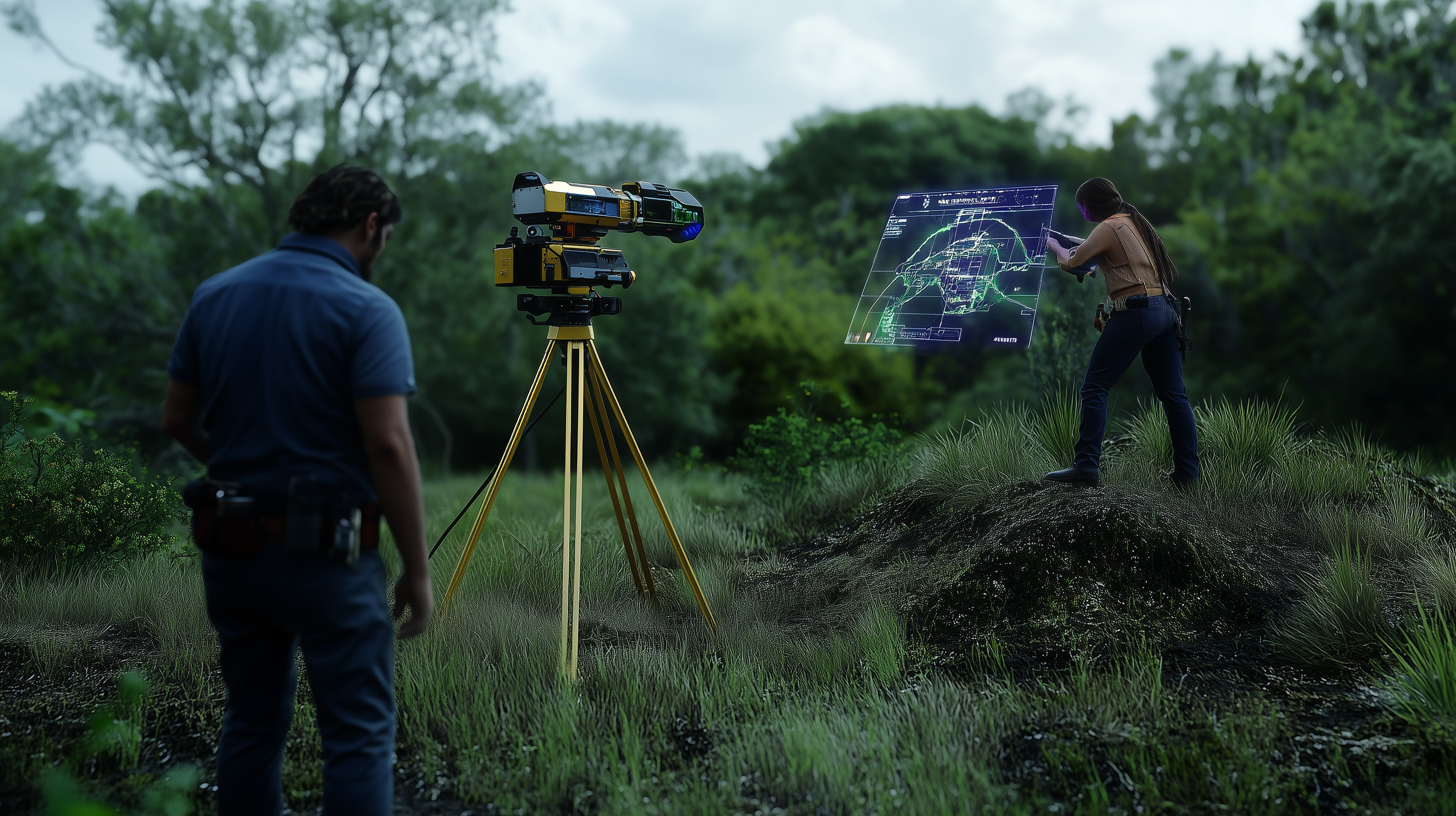
ML frameworks have transformed site detection by analyzing remotely sensed data—ranging from multispectral satellite images to UAV-derived orthophotos and LiDAR point clouds. Researchers can train models on known archaeological locales, teaching algorithms to recognize spectral or topographic signatures associated with cultural features (Menze and Ur 2012; Smith and Parsons 2020). The resulting probability maps guide targeted verification, enabling more efficient field strategies and resource allocation.
- Artifact Classification and Typology:
Traditional artifact classification is labor-intensive and often subjective. Deep learning approaches alleviate these challenges by training CNNs on carefully curated image sets. Once established, these models classify artifacts at scale, improving consistency and facilitating comparative studies across multiple collections (Smith and Parsons 2020). Incorporating thoughtful interpretive frameworks and community engagement in these analyses contributes to more meaningful cultural narratives (Driskill 2018; Flewellen 2020; Geller 2017; McDavid 2019; Supernant 2021).
- Predictive Modeling of Cultural Landscapes:
Predictive modeling correlates environmental factors—such as slope, water sources, and soil composition—with known archaeological distributions to estimate the probability of site occurrence in unexplored regions (Conolly and Lake 2006; McCoy 2022). ML algorithms, including random forests and gradient boosting machines, produce models that inform survey planning and heritage management decisions. Integrating community priorities and acknowledging data sovereignty ensures that predictive models align with culturally sensitive and ethically sound research practices (Driskill 2018; Supernant 2021).
Selecting GIS Platforms and Tools for AI Integration
Many scholars begin by using familiar GIS platforms enhanced with AI capabilities. ArcGIS Pro’s integrated deep learning tools are accessible for initial classification and object detection tasks (Esri 2023). QGIS, coupled with Python libraries (TensorFlow, PyTorch) and plugins like the Orfeo Toolbox, offers a flexible, open-source environment for more customized workflows (QGIS Documentation 2023). Additionally, cloud-based solutions such as Google Earth Engine provide large-scale computational resources and preprocessed datasets, supporting regional analyses that benefit from collaborative, theoretically informed interpretations (Google Earth Engine Documentation 2023).
Ethical and Methodological Considerations
Responsible use of AI requires acknowledging potential biases, ensuring transparent documentation, and adhering to ethical guidelines. Data sovereignty principles and collaborative research agreements safeguard cultural information and promote more equitable archaeology. Scholars should share workflows, code, and training data where appropriate to foster replicability and accountability (McDavid 2019; Driskill 2018; Supernant 2021).
Future Directions
As computational techniques evolve, archaeologists may integrate increasingly diverse datasets—geophysical surveys, historical texts, molecular evidence—into AI-driven analyses. Augmented and virtual reality interfaces could help researchers interact with predictive models, enabling immersive explorations of reconstructed past landscapes (Addison and Comstock 2004). Future work promises deeper interdisciplinary collaborations and the continuous refinement of theoretical and ethical frameworks, ensuring AI methodologies contribute to more inclusive, critically engaged archaeological scholarship.
Conclusion
Integrating AI into GIS-based archaeological research holds substantial promise, allowing scholars to navigate large datasets more efficiently and uncover patterns that might otherwise remain hidden. Archaeologists can ensure that these tools inform rather than overshadow interpretive efforts by following rigorous workflows, engaging with theoretical perspectives, and partnering with communities. Properly implemented, AI-enhanced methodologies not only streamline data analysis but also broaden the scope of archaeological inquiry, opening pathways toward richer, more contextually sensitive understandings of the human past.
Additional Resources
This section provides detailed instructions, additional resources, and external links to help readers implement and refine AI-driven GIS methodologies in archaeological research. It consolidates guidance from the discussion above and expands upon it, offering practical steps, recommended software, and community-based best practices.
- Initial Setup and Familiarization:
- Install ArcGIS Pro (if you have a license) or QGIS (open-source) to establish your GIS working environment.
- ArcGIS Pro: https://www.esri.com/en-us/arcgis/products/arcgis-pro/overview
- QGIS: https://qgis.org
- Review platform documentation for AI integration:
- ArcGIS Pro AI Tools: https://pro.arcgis.com/en/pro-app/latest/tool-reference/image-analyst/basics-deep-learning.htm
- QGIS and Orfeo Toolbox: https://www.orfeo-toolbox.org/CookBook/
- Explore Google Earth Engine for large-scale geospatial analysis: https://earthengine.google.com
- Install Python and machine learning libraries (e.g., TensorFlow, PyTorch) for custom model development:
- TensorFlow: https://www.tensorflow.org
- PyTorch: https://pytorch.org
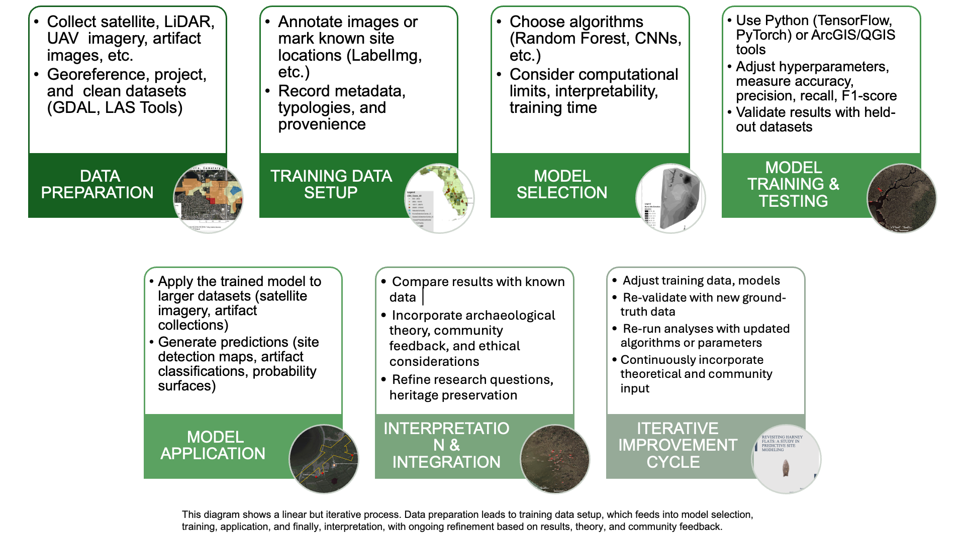
- Data Preparation and Curation:
- Ensure uniform coordinate systems and metadata standards. Consult GDAL documentation for spatial transformations: https://gdal.org
- Apply atmospheric corrections and remove noise from LiDAR datasets using specialized tools (e.g., LASTools: https://rapidlasso.com/lastools/)
- Consult archaeological best-practice guidelines for data documentation, such as the Digital Antiquity Index: https://www.digitalantiquity.org
- Training Data Collection and Annotation:
- Gather representative training samples from diverse environmental and cultural contexts.
- Annotate artifact images using open-source tools like LabelImg: https://github.com/tzutalin/labelImg
- Document each sample’s provenience, typology, and contextual details.
- Model Selection and Experimentation:
- Start with simpler ML models (e.g., random forests) via scikit-learn: https://scikit-learn.org
- Progress to deep learning methods (CNNs) for image classification tasks. Refer to example workflows from scholarly code repositories on GitHub (keyword: “archaeology AI GIS”): https://github.com
- Adjust hyperparameters iteratively, guided by performance metrics (accuracy, precision, recall, F1-score).
- Model Execution and Validation:
- Use ArcGIS ModelBuilder or QGIS Processing Models to automate workflows.
- Validate predictions against held-out test data and known archaeological distributions.
- Implement field verification campaigns for predicted high-probability areas, integrating feedback from community stakeholders and local experts.
- Interpretation and Integration:
- Treat AI outputs as starting points, informed by theory and community input.
- Engage with the work of Driskill (2018), Flewellen (2020), Geller (2017), McDavid (2019), and Supernant (2021) to understand the importance of inclusive, ethically grounded interpretations.
- Use AI findings to refine research questions, contribute to heritage management plans, and produce culturally sensitive narratives.
- Ethical Considerations and Data Sovereignty:
- Consult Indigenous data sovereignty guidelines such as the CARE Principles: https://www.gida-global.org/care
- Follow disciplinary codes of ethics, e.g., Society for American Archaeology Ethics: https://www.saa.org
- Ensure transparent documentation and consider publishing code and datasets in open repositories for peer review and community feedback.
- Further Learning and Community Engagement:
- Join professional and academic communities focusing on AI in archaeology (e.g., CAA International: https://caa-international.org).
- Attend workshops, webinars, and conferences on digital archaeology and computational methods.
- Explore additional reading:
- Gattiglia (2015) on Big Data challenges
- McCoy (2022) on geospatial big data in archaeology
- Addison and Comstock (2004) on virtual heritage and digital environments.
Sources:
- Addison, A. C., and M. Comstock. 2004 Digital Heritage and Virtual Archaeology. In Heritage Informatics, edited by J. Richards and K. Niven, pp. 23–39. Archaeopress, Oxford.
- Conolly, J., and M. Lake. 2006 Geographical Information Systems in Archaeology. Cambridge University Press, Cambridge.
- Driskill, Q. L. 2018 Digital Sovereignties: AI, Indigeneity, and Reclaiming Data in Archaeology. American Indian Quarterly 42(3):345–369.
- Esri. 2023 AI in ArcGIS Pro. Esri Documentation, Redlands, California.
- Flewellen, A. O. 2020 Decolonizing the Digital: African Diaspora Archaeology and Machine Learning. Journal of African Diaspora Archaeology and Heritage 9(2):89–110.
- Geller, P. L. 2017 Queer Approaches to Past Lives: Digital Engagement and the Archaeology of Identity. World Archaeology 49(2):276–289.
- Gattiglia, G. 2015 Think Big About Data: Archaeology and the Big Data Challenge. Archäologische Informationen 38:113–124.
- Google Earth Engine Documentation. 2023 Machine Learning on Geospatial Data. Google Earth Engine, Mountain View, California.
- McCoy, M. D. 2022 Geospatial Big Data and Archaeology: Prospects and Problems Too Big to Ignore. Journal of Computer Applications in Archaeology 5(1):55–67.
- McDavid, C. 2019 Community-Engaged Machine Learning: African American Heritage, Public Archaeology, and the Digital Turn. Public Archaeology 18(1):55–72.
- Menze, B. H., and J. A. Ur. 2012 Mapping Patterns of Long-Term Settlement in Northern Mesopotamia. Proceedings of the National Academy of Sciences 109(14):E778–E787.
- QGIS Documentation. 2023 AI Plugins and Integration. QGIS Documentation, QGIS Project.
- Smith, N., and M. Parsons. 2020 Deep Learning Applications in Archaeology. Journal of Archaeological Science 115:105094.
- Supernant, K. 2021 Mapping Métis Memories: Using GIS and AI for Indigenous Archaeologies. Journal of Community Archaeology and Heritage 8(3):210–223.
- Trier, Ø. D., R. P. Lanckriet, and C. L. Løvlie. 2019 Automatic Detection of Archaeological Objects Using Machine Learning. Archaeological Prospection 26(3):161–168.
About the Author:

Richard Ott is an anthropologist specializing in digital heritage preservation, artificial intelligence adoption, geographic information systems specialist, and researcher. He holds an MA in Anthropology/Archaeology from the University of Central Florida and has a comprehensive background in archaeology, curriculum development, management, and media production spanning over 30 years.
You can find him on LinkedIn here.
Founder